Transit Block: The Project Threatening Queens Subway Expansion

QueensLink is a proposal to open a new subway line connecting Rego Park, Forest Park, Howard Beach, and the Rockaways. Much like the Interborough Express, the project would reactivate an intact, mostly abandoned rail line to provide service to underserved neighborhoods. In the case of QueensLink, this is the former LIRR Rockaway Beach Branch, which was abandoned in 1955 except for its southern part, which was reactivated to bring the A train to the Rockaways in 1956. Put simply, QueensLink would turn currently abandoned tracks into a busy subway line serving tens of thousands of riders a day.
Unfortunately, the proposal is at risk due to a competing proposal called QueensWay. QueenWay seeks to convert the same right-of-way into a linear park with no transit service. QueensLink, in contrast, would include both transit and green space along the majority of the route, wherever there is room, including the same location as QueenLink. Regrettably, on June 30th the New York City Council is set to vote on an Adopted Budget which includes $50 million of city funding to construct the first phase of the QueensWay park, the Metro Hub, directly blocking QueensLink’s path.
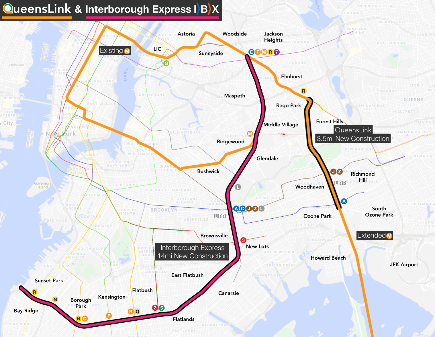
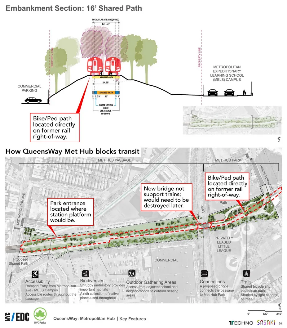
Images courtesy of QueensLink, used with permission.
According to estimates from The Transit Costs Project’s A Better Billion proposal, QueensLink would cost $2.8 billion in 2025 prices, and see ridership of 105,000 people every weekday. The high ridership is a combination of all of the following travel markets:
New service from currently unserved areas of Rego Park, Forest Park, and Woodhaven
Trips parallel to Woodhaven Boulevard, which corridor has 30,000 weekday bus riders
New trips between Manhattan and JFK, currently served by the slower A train
Leisure trips between Manhattan or Central Queens and the beaches in the Rockaways
Trips from the Rockaways, Howard Beach, and Ozone Park to Manhattan or Long Island City, currently served by the A via Lower Manhattan
Additional trips from the Queens Boulevard Line to Brooklyn, since the diversion of M trains from Forest Hills allows bringing back the G to the Queens Boulevard local tracks
Of those 105,000 projected riders, 75,000 are expected to be entirely new subway riders. The other 30,000 would come from riders living in the Rockaways who currently must endure very long trips to Manhattan along the A. QueensLink would provide them a far faster trip to Midtown. With all of these types of riders combined, the overall costs and ridership compare favorably with Second Avenue Subway and the Interborough Express:
| Project | Length (mi) | Cost (2025$) | Ridership/day | Cost/rider |
|---|---|---|---|---|
| SAS Phase 1 | 1.7 | $6,600,000,000 | 202,000 | $33,000 |
| SAS Phase 2 | 1.6 | $6,900,000,000 | 101,000 | $69,000 |
| Interborough Express | 14 | $5,500,000,000 | 160,000 | $34,000 |
| QueensLink | 3.5 | $2,800,000,000 | 105,000 | $27,000 |
In short, by building on an existing right-of-way, QueensLink can serve a huge number of riders for a comparatively affordable cost. If QueensWay is built, however, it will sever this part of the corridor, either meaning the park would have to be demolished in the future (a difficult proposition) or a long and expensive subway would need to be built under Woodhaven Boulevard.
The Rockaway Beach Branch is a unique opportunity for New York: a publicly owned right-of-way in a dense urban corridor with high property value. Corridors like that do not grow on trees, and any city would be foolish not to take advantage. The best plan for New York’s future is QueensLink.